|
Size: 673
Comment:
|
Size: 2460
Comment:
|
| Deletions are marked like this. | Additions are marked like this. |
| Line 7: | Line 7: |
| http://maps.google.it/maps/ms?hl=it&gl=it&ptab=2&ie=UTF8&oe=UTF8&msa=0&msid=102163358171818030455.0004813a6dad2d93243fc&t=h&z=17 | |
| Line 9: | Line 8: |
| {{attachment:powermapthumb.jpg}} | * [[http://www.openstreetmap.org/?minlon=12.0041132655&minlat=41.9326959735&maxlon=12.3241132655&maxlat=42.2526959735 | OSMap]]. * [[http://maps.google.com/maps?f=q&source=s_q&hl=en&geocode=&q=Bracciano+RM,+Italy&sll=37.0625,-95.677068&sspn=36.042042,35.595703&ie=UTF8&hq=&hnear=Bracciano+Rome,+Lazio,+Italy&t=h&ll=42.106079,12.188033&spn=0.002062,0.002173&z=18 | gmaps aerial view]] |
| Line 11: | Line 11: |
| [[attachment:powermap.jpg]] | * http://maps.google.it/maps/ms?hl=it&gl=it&ptab=2&ie=UTF8&oe=UTF8&msa=0&msid=102163358171818030455.0004813a6dad2d93243fc&t=h&z=17 |
| Line 13: | Line 13: |
| [[attachment:PowerPlugs.gpx]] | * http://www.gpsvisualizer.com/display/data/1268036431-07653-78.29.250.237.html [[attachment:powermap.jpg|{{attachment:powermapthumb.jpg}}]] * Hand Made Topological Map (in red the last IP digit of the 45 deployed nodes over the camp) [[attachment:hand-made-topological-map.jpg|{{attachment:powermap2thumb.jpg}}]] * Text file with description of the location of the node over the camp [[attachment:map-sorted.txt]] [[attachment:poweroverlay.jpg|{{attachment:thumb_poweroverlay.jpg}}]] FREE PLUGS ("-" means free but not working) ||col. n. || free plugs || ||1||1, 3|| ||2||2|| ||3|| NOT EXISTS|| ||4||3|| ||5||1 (dirty)|| ||6||-2|| ||7||1,2|| ||8|| NO FREE PLUGS|| ||9|| 1|| ||10||3,-5,-6|| ||11||1,2|| ||12||-1|| ||13||1,3|| ||14||-2|| ||15||4|| ||16||2,3|| ||17||2,-3|| ||18||1,2,-3|| ||19||1,2,-3|| ||20|| NOT EXISTS || ||21||1,2,3|| ||22||1,2,3|| ||23||2,3|| ||24||1,2,3|| ||25||1,2,3|| ||26||5,6,7|| ||27||1,3|| ||28||1,2,3|| ||29||UPPER PLUGS FULL, 5, -6|| ||30||1,2|| ||31 (32 on the map)|| NO FREE PLUGS|| ||32 (31 on the map)||2|| ||33||-1,-2|| |
| Line 17: | Line 61: |
| [[attachment:samplepowercolumn.jpg]] [[attachment:treesandplugsites.jpg]] | [[attachment:A_SIGN.jpg|{{attachment:thumb_A_SIGN.jpg}}]] [[attachment:B_SIGN.jpg|{{attachment:thumb_B_SIGN.jpg}}]] [[attachment:C_SIGN.jpg|{{attachment:thumb_C_SIGN.jpg}}]] [[attachment:E_SIGN.jpg|{{attachment:thumb_E_SIGN.jpg}}]] [[attachment:samplepowercolumn.jpg|{{attachment:thumb_samplepowercolumn.jpg}}]] [[attachment:treesandplugsites.jpg|{{attachment:thumb_treesandplugsites.jpg}}]] |
| Line 21: | Line 72: |
| [[attachment:PowerPlugs.gpx]] [[attachment:Trk_10-03-07_13-13-17.xml]] == OpenStreet Maps data == == GPS informations == |
* GPS data matched with the map in the picture: [[attachment:PowerPlugs.gpx]] * Original GPS data: [[attachment:Trk_10-03-07_13-13-17.xml]] |
| Line 29: | Line 77: |
| [[attachment:blueplug.jpg]] Camping (blue) plug 3 pin 220V | [[attachment:blueplug.jpg|{{attachment:thumb_blueplug.jpg}}]] Camping (blue) plug 3 pin 220V |
Map
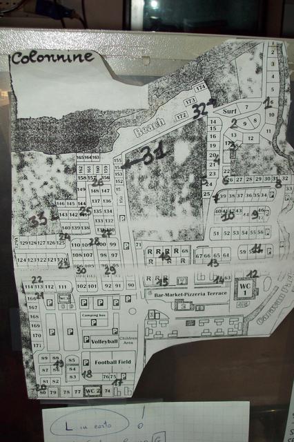
This page is dedicated to the site map of the camping for the WBMv3
Contents
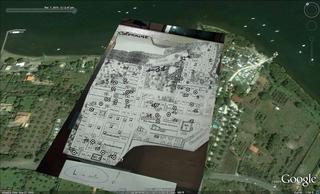
Map
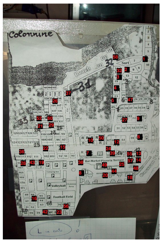
- Hand Made Topological Map (in red the last IP digit of the 45 deployed nodes over the camp)
Text file with description of the location of the node over the camp map-sorted.txt
FREE PLUGS ("-" means free but not working)
col. n. |
free plugs |
1 |
1, 3 |
2 |
2 |
3 |
NOT EXISTS |
4 |
3 |
5 |
1 (dirty) |
6 |
-2 |
7 |
1,2 |
8 |
NO FREE PLUGS |
9 |
1 |
10 |
3,-5,-6 |
11 |
1,2 |
12 |
-1 |
13 |
1,3 |
14 |
-2 |
15 |
4 |
16 |
2,3 |
17 |
2,-3 |
18 |
1,2,-3 |
19 |
1,2,-3 |
20 |
NOT EXISTS |
21 |
1,2,3 |
22 |
1,2,3 |
23 |
2,3 |
24 |
1,2,3 |
25 |
1,2,3 |
26 |
5,6,7 |
27 |
1,3 |
28 |
1,2,3 |
29 |
UPPER PLUGS FULL, 5, -6 |
30 |
1,2 |
31 (32 on the map) |
NO FREE PLUGS |
32 (31 on the map) |
2 |
33 |
-1,-2 |
JPG
GPX data
GPS data matched with the map in the picture: PowerPlugs.gpx
Original GPS data: Trk_10-03-07_13-13-17.xml

